TruWeather Solutions’ Weather Sensor Network Blankets the Nation

Unparalleled Mircroweather Data & Insights From The Ground Up
Weather can bring flight times to a standstill. To TruWeather Solutions, that downtime is called the “weather tax”. As uncrewed aircraft systems (UAS) and advanced air mobility (AAM) operations scale, and schedules become tighter, this “weather tax” - can quickly add up. And time equals money.
This problem persists because of the low altitude weather “data desert,” gaps in microclimate conditions at low altitudes. This lack of clarity leads to faulty operational decision-making.
To address this problem, TruWeather Solutions has been building out a national multi-domain network of weather sensors. This network will create an “MRI,” or diagnostic-level picture, of the low level atmosphere in high density drone traffic areas, aid in delivering the most accurate “nowcast” information…and keep autonomous systems flying.
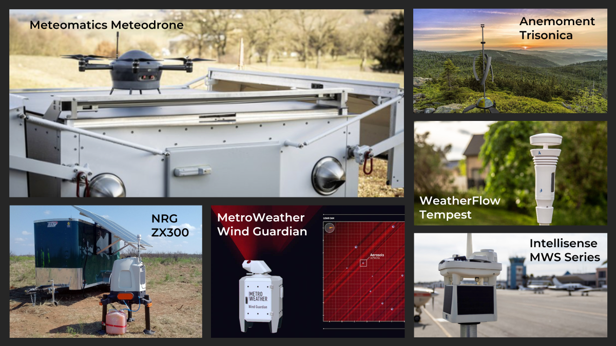
TruWeather Solutions’ network of sensors includes mobile weather stations, ground-based detect and alert systems, and wind lidars to provide accurate, real-time weather data like wind, temperature, pressure, humidity, precipitation, visibility, and ceiling height for unmanned aerial systems (UAS) and advanced air mobility (AAM) operations.
The company partners with companies, municipalities, organizations and investors who purchase and deploy these sensors to integrate into TruWeather’s “system of systems.” This provides a one-stop shop to allow users to look at different observations in one place.
“We can essentially crowdsource data from all of these different sensors, stitch it together to close the data gaps for more granular micro weather where drones fly.” TruWeather’s CEO, Don Berchoff, explained. Berchoff, the former National Weather Service S&T lead and a retired U.S. Air Force Colonel, has over 28 years of government weather experience.
Each sensor provides different types of information. For example, a low cost weather station feeds real-time observed weather data from any given location into a machine learning system to dramatically improve forecast accuracy. This allows users to obtain more information at specific flight locations from lightning strike data to precipitate pressure.
The dual-use mobile tactical Intellisense Microweather Station can provide ceiling heights and visibility along flight routes. Approximately seven times cheaper than sensors deployed at the airports, it reports highly-accurate temperature, pressure, humidity, wind speed and direction, peak gusts and precipitation amounts. One or two of these sensors deployed along a flight route can buttress beyond visual line of sight (BVLOS) waiver packages to the FAA. This allows a user to say they are actually measuring the ceiling and the visibility along their route to satisfy the FAA’s regulatory requirement to maintain 500 foot clearance from the clouds.
“You need to understand what's really happening, especially when you fly BVLOS,” Berchoff noted. “BVLOS requires much more weather awareness than we have today. The pilot is not on the aircraft anymore to see and experience the weather. TruWeather is trying to backfill that lack of information, through a variety of sensors, providing the same level of fidelity as if the pilot was flying through that area.”
With regard to winds above ground level, TruWeather has partnered with Switzerland-based Meteomatics’ to deploy its Meteodrone. A mobile weather station, this 6-rotor electric vertical take-off-and-landing (eVTOL) UAS can collect high-resolution and direct temperature, humidity, barometric pressure and wind measurements at altitudes of up to 16,900 feet. The Meteodrone’s rotor heating system allows it to fly safely in extreme conditions, enabling ice detection in clouds and providing critical information for UAS operators to enhance safety-of-flight and repeatable large BVLOS operations.
TruWeather has also deployed two Metro Weather Wind Guardians at its urban test bed with NASA in Hampton, Virginia. The Lidar is a scanning lidar and looks for dust and particles in the air. Using Doppler technology, they can track the movement of those particles and how the winds are behaving aloft. This could cover a 20 kilometer area up to six thousand feet at 10 meter resolution. This provides a 3D view of the atmosphere to see the winds and the currents. The deployment of sensors is more cost effective for operators than one might expect. By amortizing the system cost against large numbers of UAS and AAM missions, driving down the cost per operator makesit affordable. Berchoff predicts this will equate to about 3 to 1 return on investment.
“The data from these Wind Guardians is going to be amazing for power consumption optimization,” Berchoff noted. “It will help pilots know how far they can fly and whether they will get there on time. If you've got a strong headwind, are you going to be able to deliver your goods to meet the contract that you have with your clients?”
The company also deploys the NRG Lidar for point locations. Cheaper than the scanning lidar, these provide a single beam of lidar at a point that could visualize winds up to 800 feet above ground level. These will help measure winds aloft and alert users to wind shear. The lidars are easily deployable and can be attached to mobile command posts to provide key information in the field, such as in disaster recovery operations.
“You're trying to get drones up in the air as soon as possible after a disaster. If you're waiting because you don't know what those winds are doing, you're losing precious time to find people that are trapped in rubble or identify and assess the damage that has been done,” Berchoff said.
TruWeather also uses the LiCor (formerly Anemoment) Trisonica Wind & Weather Sensor, the world’s smallest and lightest 3D ultrasonic anemometer. In addition to wind speed, direction, and temperature, it can report the compass heading relative to the device (magnetic heading), the moisture borne in the wind (relative humidity), the density of the air (pressure), dew point, and the angle of the wind (pitch and roll, up to a 15° tilt). This small versatile sensor can be placed atop vans, towers as well as UAS.
According to Bercoff, in Hampton, his team is bringing all these sensor capabilities together in what he refers to as “a playground for sensors”' for NASA’s high density vertiport AAM flight operations. Working with Longbow’s Pegasus airspace navigation system to tie all this system data together, he plans to demonstrate the value of fully integrated microweather into specific corridors, to maximize efficiency and effectiveness in urban air mobility (UAM) operations.
“TruWeather tackles the toughest problems: the ceiling and visibility problem, the turbulence problem, the icing problem and the thunderstorm initiation problem,” Berchoff noted. “We do this using a variety of instruments and measurements that will provide the data we can integrate and turn it into insights.”
Most other weather companies charge thousands of dollars just to integrate this kind of data. Even then, few integrate data of the 3D environment into an API workflow like TruWeather and provide a one-stop-shop for all weather information. TruWeather also provides training on the tactics, techniques and procedures to enable companies to get the full value of this data to optimize operations.
“We want to make it a simple workflow. We don't want you to have to look at a sensor on one screen or four or five weather apps on another screen,” explained Berchoff. “This is the power of weather data from the ground up that TruWeather Solutions provides.”
TruWeather Solutions aims to help businesses to fly safely with 30 percent more flight time when otherwise grounded and enabling 100% flights in weather-tolerant windows. It does this by providing better weather data derived from an extensive sensor network to identify low altitude weather that is actually happening, in real time.
This is why TruWeather Solutions is the low altitude weather specialists that keep an eye on the weather for you from the ground up.
Visit TruWeather Solutions along with some of their sensor partners at the Weather Pavillion at AUVSI XPONENTIAL 2023: #2637
Watch the Exclusive Announcement: TruWeather's Weather Network Innovation from the Ground Up: https://www.youtube.com/watch?v=yji5mWm4hYo&t=2s
To plug into the TruWeather Solutions network, contact: lisa.tinnesz@truweathersolutions.com

Related


